


05 Dévoluy Vallon-Abeou

Nathy8913
Gebruiker
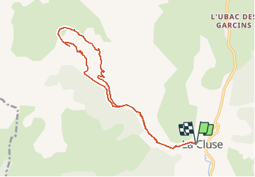

Lengte
8,9 km

Max. hoogte
1641 m

Positief hoogteverschil
420 m
Km-Effort
14,5 km

Min. hoogte
1228 m

Negatief hoogteverschil
420 m
Boucle
Ja
Datum van aanmaak :
2020-05-29 12:30:16.002
Laatste wijziging :
2020-05-29 12:30:34.967

Gratisgps-wandelapplicatie
 SityTrail
IGN / Geografische instituten
SityTrail Plus
De wereld gaat voor u open
Over ons
Tocht van 8,9 km beschikbaar op Provence-Alpes-Côte d'Azur, Hautes-Alpes, Le Dévoluy. Deze tocht wordt voorgesteld door Nathy8913.
Plaatsbepaling
Land:
France
Regio :
Provence-Alpes-Côte d'Azur
Departement/Provincie :
Hautes-Alpes
Gemeente :
Le Dévoluy
Locatie:
Unknown
Vertrek:(Dec)
Vertrek:(UTM)
725789 ; 4946852 (31T) N.
Opmerkingen