


Concession

sameja
Gebruiker
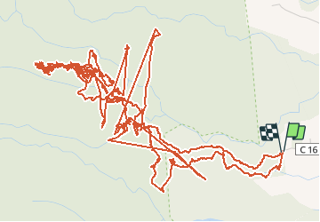

Lengte
27 km

Max. hoogte
779 m

Positief hoogteverschil
1737 m
Km-Effort
50 km

Min. hoogte
388 m

Negatief hoogteverschil
1746 m
Boucle
Ja
Datum van aanmaak :
2020-05-31 10:14:24.0
Laatste wijziging :
2020-05-31 19:31:51.987
5h28
Moeilijkheid :

Gratisgps-wandelapplicatie
 SityTrail
IGN / Geografische instituten
SityTrail Plus
De wereld gaat voor u open
Over ons
Tocht Trail van 27 km beschikbaar op Guadeloupe, Onbekend, Capesterre-Belle-Eau. Deze tocht wordt voorgesteld door sameja.
Beschrijving
Foret Capesterre Belle Eau
Foto's


Plaatsbepaling
Land:
France
Regio :
Guadeloupe
Departement/Provincie :
Onbekend
Gemeente :
Capesterre-Belle-Eau
Locatie:
Unknown
Vertrek:(Dec)
Vertrek:(UTM)
647665 ; 1775166 (20Q) N.
Opmerkingen