


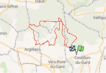
Castillon - Argilliers - Boucles

mthomas30
Gebruiker

Lengte
25 km

Max. hoogte
192 m

Positief hoogteverschil
395 m
Km-Effort
30 km

Min. hoogte
61 m

Negatief hoogteverschil
394 m
Boucle
Ja
Datum van aanmaak :
2020-06-01 06:24:01.651
Laatste wijziging :
2020-07-13 10:34:43.884
2h43
Moeilijkheid : Medium

Gratisgps-wandelapplicatie
 SityTrail
IGN / Geografische instituten
SityTrail Plus
De wereld gaat voor u open
Over ons
Tocht Mountainbike van 25 km beschikbaar op Occitanië, Gard, Castillon-du-Gard. Deze tocht wordt voorgesteld door mthomas30.
Beschrijving
Sur les traces du club des crickets de Remoulins. Départ chapelle St Caprés, Belle boucle plein de monotraces.
Plaatsbepaling
Land:
France
Regio :
Occitanië
Departement/Provincie :
Gard
Gemeente :
Castillon-du-Gard
Locatie:
Unknown
Vertrek:(Dec)
Vertrek:(UTM)
624122 ; 4870242 (31T) N.
Opmerkingen