


VTT - Tasie - 1

frizou83
Gebruiker
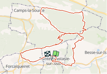

Lengte
31 km

Max. hoogte
543 m

Positief hoogteverschil
669 m
Km-Effort
40 km

Min. hoogte
264 m

Negatief hoogteverschil
669 m
Boucle
Ja
Datum van aanmaak :
2020-06-06 05:21:27.211
Laatste wijziging :
2020-06-06 05:33:11.085
48m
Moeilijkheid : Gemakkelijk

Gratisgps-wandelapplicatie
 SityTrail
IGN / Geografische instituten
SityTrail Plus
De wereld gaat voor u open
Over ons
Tocht Mountainbike van 31 km beschikbaar op Provence-Alpes-Côte d'Azur, Var, Sainte-Anastasie-sur-Issole. Deze tocht wordt voorgesteld door frizou83.
Plaatsbepaling
Land:
France
Regio :
Provence-Alpes-Côte d'Azur
Departement/Provincie :
Var
Gemeente :
Sainte-Anastasie-sur-Issole
Locatie:
Unknown
Vertrek:(Dec)
Vertrek:(UTM)
266724 ; 4802915 (32T) N.
Opmerkingen