Tocht Stappen Saint-Raphaël - Pic du Cap Roux, l'Esterel - Photo
 Sugg
Sugg

Gebruiker

© OpenStreetMap contributors
Lengte
Lengte
11,5 km
Max. hoogte
Max. hoogte
440 m
Positief hoogteverschil
555 m
Km-Effort
Km-Effort  
18,9 km
Min. hoogte
Min. hoogte
59 m
Negatief hoogteverschil
559 m
Boucle
Boucle
Ja
Datum van aanmaak :
2019-03-22 17:00:19.457
Laatste wijziging :
2019-03-22 17:00:19.612

(0 Bericht)

Stappen
Stappen
4h16
Moeilijkheid : Medium

Scan deze QR-code om de tocht te openen in de SityTrail-applicatie

Gratisgps-wandelapplicatie

Logo SityTrail SityTrail

IGN / Geografische instituten

SityTrail uit de App Store downloaden SityTrail uit Google Play downloaden

Logo SityTrail SityTrail Plus

De wereld gaat voor u open

SityTrail uit de App Store downloaden SityTrail uit Google Play downloaden SityTrail op Huawei AppGallery downloaden

Over ons

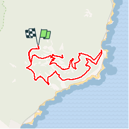
Tocht Stappen van 11,5 km beschikbaar op Provence-Alpes-Côte d'Azur, Var, Saint-Raphaël. Deze tocht wordt voorgesteld door Sugg.

Beschrijving

15-01-2014
Une variante de plus...
Départ du parking sous la grotte chapelle " la sainte Baume ", non visitée pour cette fois, montée a la table d'orientation du Pic du Cap Roux ( vue 360° très dégagée ce matin ),redescente plein Est vers la pointe de Maubois, puis le rocher de St Barthélémy, le col de St Pilon, et retour à la case départ.Temps magnifique, soleil et pas de vent.Attention dans les éboulis.

Hoogteprofiel

Foto's

Plaatsbepaling

Land:
France
Regio :
Provence-Alpes-Côte d'Azur
Departement/Provincie :
Var
Gemeente :
Saint-Raphaël
Locatie:
Unknown
Vertrek:(Dec)
Vertrek:(UTM)
329941 ; 4813747 (32T) N.


Sluiten
Mijn abonnementen