Tocht Auto Wingles - Route vers les Steven étang - Photo

Route vers les Steven étang

 yves62410
yves62410

Gebruiker

© OpenStreetMap contributors
Lengte
Lengte
79 km
Max. hoogte
Max. hoogte
114 m
Positief hoogteverschil
644 m
Km-Effort
Km-Effort  
87 km
Min. hoogte
Min. hoogte
0 m
Negatief hoogteverschil
671 m
Boucle
Boucle
Neen
Datum van aanmaak :
2020-06-21 09:27:28.0
Laatste wijziging :
2020-06-21 10:30:19.485

(0 Bericht)

Auto
Auto
1h02
Moeilijkheid : Onbekend

Scan deze QR-code om de tocht te openen in de SityTrail-applicatie

Gratisgps-wandelapplicatie

Logo SityTrail SityTrail

IGN / Geografische instituten

SityTrail uit de App Store downloaden SityTrail uit Google Play downloaden

Logo SityTrail SityTrail World

De wereld gaat voor u open

SityTrail uit de App Store downloaden SityTrail uit Google Play downloaden SityTrail op Huawei AppGallery downloaden

Over ons

Tocht Auto van 79 km beschikbaar op Hauts-de-France, Pas-de-Calais, Wingles. Deze tocht wordt voorgesteld door yves62410.

Beschrijving

Dires

Hoogteprofiel

Plaatsbepaling

Land:
France
Regio :
Hauts-de-France
Departement/Provincie :
Pas-de-Calais
Gemeente :
Wingles
Locatie:
Unknown
Vertrek:(Dec)
Vertrek:(UTM)
488744 ; 5593091 (31U) N.

Wandeltochten in de omgeving

Tocht Hybride fiets Wingles - Wingles parc de la souchez - Photo
Hybride fiets
yves62410

Hybride fiets

(1)
Wingles, Hauts-de-France, Pas-de-Calais, France
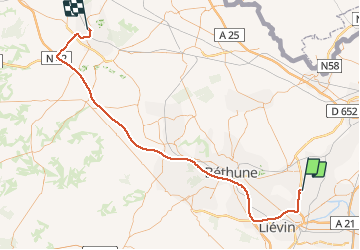
34 km | 36 km-effort
1h 53min
Ja
Tocht Stappen La Bassée - La Basée 13 km - Photo
Stappen
GUIDE
rvapeldo

Stappen

Gemakkelijk
La Bassée, Hauts-de-France, Noorderdepartement, France
13 km | 13,7 km-effort
3h 26min
Ja
Tocht Stappen Bauvin - Wingles - Photo
Stappen
sandrine brisset

Stappen

Medium
Bauvin, Hauts-de-France, Noorderdepartement, France
11,8 km | 13 km-effort
3h 25min
Neen
Tocht Elektrische fiets Wingles - Wingles BÈthune vimy - Photo
Elektrische fiets
yves62410

Elektrische fiets

Medium
Wingles, Hauts-de-France, Pas-de-Calais, France
82 km | 92 km-effort
5h 32min
Ja
Tocht Stappen Haisnes - La gare - Haisnes - Photo
Stappen
tracegps

Stappen

Medium
Haisnes, Hauts-de-France, Pas-de-Calais, France
10,1 km | 10,8 km-effort
2h 30min
Ja
Tocht Stappen Billy-Berclau - Le chemin vert - Billy-Berclau - Photo
Stappen
tracegps

Stappen

Medium
Billy-Berclau, Hauts-de-France, Pas-de-Calais, France
9,2 km | 9,7 km-effort
2h 15min
Ja
Tocht Stappen Auchy-les-Mines - Les Briques - Auchy les Mines - Photo
Stappen
tracegps

Stappen

Gemakkelijk
Auchy-les-Mines, Hauts-de-France, Pas-de-Calais, France
6,7 km | 7 km-effort
1h 40min
Ja
Tocht Fiets Wingles - Les parcs - Wingles - Photo
Fiets
tracegps

Fiets

Gemakkelijk
(1)
Wingles, Hauts-de-France, Pas-de-Calais, France
29 km | 31 km-effort
2h 0min
Ja
Tocht Stappen Hantay - Circuit découverte nature des Weppes - Hantay - Photo
Stappen
tracegps

Stappen

Medium
(2)
Hantay, Hauts-de-France, Noorderdepartement, France
9,2 km | 9,8 km-effort
2h 19min
Ja


Sluiten
Mijn abonnementen