


Circuit du bois Noir

frizou83
Gebruiker
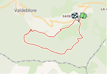

Lengte
7,9 km

Max. hoogte
1549 m

Positief hoogteverschil
452 m
Km-Effort
14 km

Min. hoogte
1088 m

Negatief hoogteverschil
456 m
Boucle
Ja
Datum van aanmaak :
2020-06-28 15:37:25.688
Laatste wijziging :
2020-06-28 15:38:05.37
2h49
Moeilijkheid : Moeilijk

Gratisgps-wandelapplicatie
 SityTrail
IGN / Geografische instituten
SityTrail Plus
De wereld gaat voor u open
Over ons
Tocht Stappen van 7,9 km beschikbaar op Provence-Alpes-Côte d'Azur, Alpes-Maritimes, Valdeblore. Deze tocht wordt voorgesteld door frizou83.
Plaatsbepaling
Land:
France
Regio :
Provence-Alpes-Côte d'Azur
Departement/Provincie :
Alpes-Maritimes
Gemeente :
Valdeblore
Locatie:
Unknown
Vertrek:(Dec)
Vertrek:(UTM)
356092 ; 4880724 (32T) N.
Opmerkingen