


clintest
Gebruiker
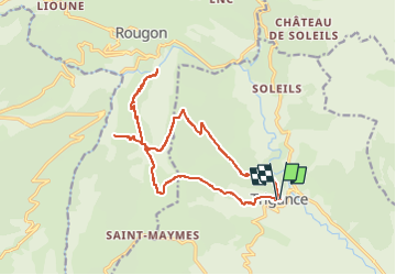

Lengte
19,1 km

Max. hoogte
1156 m

Positief hoogteverschil
990 m
Km-Effort
32 km

Min. hoogte
624 m

Negatief hoogteverschil
978 m
Boucle
Ja
Datum van aanmaak :
2020-07-02 12:39:05.639
Laatste wijziging :
2020-07-02 12:39:05.639

Gratisgps-wandelapplicatie
 SityTrail
IGN / Geografische instituten
SityTrail Plus
De wereld gaat voor u open
Over ons
Tocht van 19,1 km beschikbaar op Provence-Alpes-Côte d'Azur, Var, Trigance. Deze tocht wordt voorgesteld door clintest.
Plaatsbepaling
Land:
France
Regio :
Provence-Alpes-Côte d'Azur
Departement/Provincie :
Var
Gemeente :
Trigance
Locatie:
Unknown
Vertrek:(Dec)
Vertrek:(UTM)
294387 ; 4848553 (32T) N.
Opmerkingen