Tocht Stappen Nassogne - nassogne ac - Photo
 colsonandre
colsonandre

Gebruiker

© OpenStreetMap contributors
Lengte
Lengte
39 km
Max. hoogte
Max. hoogte
533 m
Positief hoogteverschil
687 m
Km-Effort
Km-Effort  
48 km
Min. hoogte
Min. hoogte
172 m
Negatief hoogteverschil
757 m
Boucle
Boucle
Neen
Datum van aanmaak :
2020-07-04 07:13:11.644
Laatste wijziging :
2020-07-04 12:44:53.889

(1 Bericht)

Stappen
Stappen
5h30
Moeilijkheid : Medium

Scan deze QR-code om de tocht te openen in de SityTrail-applicatie

Gratisgps-wandelapplicatie

Logo SityTrail SityTrail

IGN / Geografische instituten

SityTrail uit de App Store downloaden SityTrail uit Google Play downloaden

Logo SityTrail SityTrail World

De wereld gaat voor u open

SityTrail uit de App Store downloaden SityTrail uit Google Play downloaden SityTrail op Huawei AppGallery downloaden

Over ons

Tocht Stappen van 39 km beschikbaar op Wallonië, Luxemburg, Nassogne. Deze tocht wordt voorgesteld door colsonandre.

Beschrijving

très belle et un peu de travail d'orientation

Hoogteprofiel

Foto's

Plaatsbepaling

Land:
Belgium
Regio :
Wallonië
Departement/Provincie :
Luxemburg
Gemeente :
Nassogne
Locatie:
Nassogne
Vertrek:(UTM)
667654 ; 5555306 (31U) N.

Opmerkingen

Gelieve in te loggen om een commentaar of een beoordeling achter te laten


magnifique, dommage que le trajet du retour à la maison se soit imprimé sinon 9.6 km


Wandeltochten in de omgeving

Tocht Stappen Tellin - GG-Lu-13_Grupont - Poix-Saint-Hubert - Photo
Stappen
PRO

Stappen

Zeer moeilijk
(2)
Tellin, Wallonië, Luxemburg, Belgium
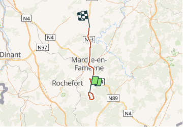
26 km | 34 km-effort
7h 23min
Neen
Tocht Stappen Tellin - Balade à Grupont - Photo
Stappen
GUIDE
Desrumaux

Stappen

Gemakkelijk
(1)
Tellin, Wallonië, Luxemburg, Belgium
8,4 km | 11,9 km-effort
2h 33min
Ja
Tocht Stappen Tellin - Grupont - Promenade du Bois du Machi - Photo
Stappen
GUIDE+

Stappen

Medium
(1)
Tellin, Wallonië, Luxemburg, Belgium
8,6 km | 12,6 km-effort
2h 37min
Ja
Tocht Mountainbike Nassogne - Nassogne - Circuit VTT rouge 4 - Photo
Mountainbike
GUIDE+

Mountainbike

Moeilijk
(1)
Nassogne, Wallonië, Luxemburg, Belgium
26 km | 36 km-effort
2h 16min
Ja
Tocht Stappen Nassogne - Grune - Promenade du Chevenys (NG 11) - Photo
Stappen
GUIDE+

Stappen

Medium
(3)
Nassogne, Wallonië, Luxemburg, Belgium
8,4 km | 11,6 km-effort
2h 27min
Ja
Tocht Stappen Nassogne - Grune - Promenade des Prés (NG 10) - Photo
Stappen
GUIDE+

Stappen

Gemakkelijk
(1)
Nassogne, Wallonië, Luxemburg, Belgium
4,4 km | 5,3 km-effort
1h 10min
Ja
Tocht Stappen Nassogne - Forrières/Lesterny - Promenade Saint-Martin (NG 08) - Photo
Stappen
GUIDE+

Stappen

Medium
(4)
Nassogne, Wallonië, Luxemburg, Belgium
7,3 km | 9 km-effort
1h 57min
Ja
Tocht Stappen Nassogne - Forrières - Promenade de Cocher (NG 07) - Photo
Stappen
GUIDE+

Stappen

Medium
(2)
Nassogne, Wallonië, Luxemburg, Belgium
5,4 km | 6,7 km-effort
1h 28min
Ja
Tocht Stappen Nassogne - Ambly - Promenade de Javingue (NG 02) - Photo
Stappen
GUIDE+

Stappen

Medium
(7)
Nassogne, Wallonië, Luxemburg, Belgium
9 km | 11,6 km-effort
2h 28min
Ja


Sluiten
Mijn abonnementen