


Vendredi AM Col de Vars

jcm17
Gebruiker
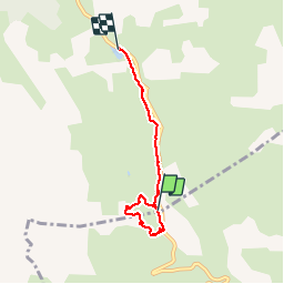

Lengte
4,5 km

Max. hoogte
2170 m

Positief hoogteverschil
77 m
Km-Effort
5,9 km

Min. hoogte
1989 m

Negatief hoogteverschil
194 m
Boucle
Neen
Datum van aanmaak :
2014-12-10 00:00:00.0
Laatste wijziging :
2014-12-10 00:00:00.0
1h56
Moeilijkheid : Gemakkelijk

Gratisgps-wandelapplicatie
 SityTrail
IGN / Geografische instituten
SityTrail Plus
De wereld gaat voor u open
Over ons
Tocht Sneeuwschoenen van 4,5 km beschikbaar op Provence-Alpes-Côte d'Azur, Hautes-Alpes, Vars. Deze tocht wordt voorgesteld door jcm17.
Beschrijving
Tour au Col de Vars vers l’igloo puis la Chapelle Ste Marie-Madeleine, suivi d'une descente jusqu'au Refuge Napoléon?


Plaatsbepaling
Land:
France
Regio :
Provence-Alpes-Côte d'Azur
Departement/Provincie :
Hautes-Alpes
Gemeente :
Vars
Locatie:
Unknown
Vertrek:(Dec)
Vertrek:(UTM)
317451 ; 4934303 (32T) N.
Opmerkingen