


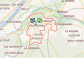
Rivarennes - Circuit 1 - 18.2km 225m 3h55 - 2020 07 13

Orcal37
Gebruiker GUIDE

Lengte
18,2 km

Max. hoogte
116 m

Positief hoogteverschil
224 m
Km-Effort
21 km

Min. hoogte
33 m

Negatief hoogteverschil
224 m
Boucle
Ja
Datum van aanmaak :
2020-07-13 12:35:02.591
Laatste wijziging :
2020-07-13 18:58:00.63
3h55
Moeilijkheid : Gemakkelijk

Gratisgps-wandelapplicatie
 SityTrail
IGN / Geografische instituten
SityTrail Plus
De wereld gaat voor u open
Over ons
Tocht Stappen van 18,2 km beschikbaar op Centre-Val de Loire, Indre-et-Loire, Rivarennes. Deze tocht wordt voorgesteld door Orcal37.
Beschrijving
Rivarennes - Circuit 1 - 18.2km 225m 3h55 - 2020 07 13
Beau circuit varié.
Foto's


Plaatsbepaling
Land:
France
Regio :
Centre-Val de Loire
Departement/Provincie :
Indre-et-Loire
Gemeente :
Rivarennes
Locatie:
Unknown
Vertrek:(Dec)
Vertrek:(UTM)
299872 ; 5238209 (31T) N.
Opmerkingen