


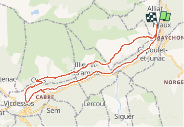
Niaux - Vicdessos

pmauvieux
Gebruiker

Lengte
22 km

Max. hoogte
1046 m

Positief hoogteverschil
820 m
Km-Effort
33 km

Min. hoogte
556 m

Negatief hoogteverschil
817 m
Boucle
Ja
Datum van aanmaak :
2020-07-15 05:55:27.479
Laatste wijziging :
2020-07-16 14:07:58.353
7h56
Moeilijkheid : Medium

Gratisgps-wandelapplicatie
 SityTrail
IGN / Geografische instituten
SityTrail Plus
De wereld gaat voor u open
Over ons
Tocht Stappen van 22 km beschikbaar op Occitanië, Ariège, Alliat. Deze tocht wordt voorgesteld door pmauvieux.
Plaatsbepaling
Land:
France
Regio :
Occitanië
Departement/Provincie :
Ariège
Gemeente :
Alliat
Locatie:
Unknown
Vertrek:(Dec)
Vertrek:(UTM)
384614 ; 4740429 (31T) N.
Opmerkingen