


Disque jaune GrangeSt Barthélemy

GR5 2020
Gebruiker

Lengte
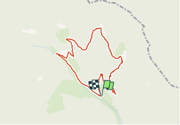
4,3 km

Max. hoogte
681 m

Positief hoogteverschil
194 m
Km-Effort
6,9 km

Min. hoogte
474 m

Negatief hoogteverschil
194 m
Boucle
Ja
Datum van aanmaak :
2020-07-20 07:38:34.258
Laatste wijziging :
2020-07-27 16:46:08.651
3h16
Moeilijkheid : Heel gemakkelijk

Gratisgps-wandelapplicatie
 SityTrail
IGN / Geografische instituten
SityTrail Plus
De wereld gaat voor u open
Over ons
Tocht Stappen van 4,3 km beschikbaar op Grand Est, Haut-Rhin, Sainte-Croix-aux-Mines. Deze tocht wordt voorgesteld door GR5 2020.
Plaatsbepaling
Land:
France
Regio :
Grand Est
Departement/Provincie :
Haut-Rhin
Gemeente :
Sainte-Croix-aux-Mines
Locatie:
Unknown
Vertrek:(Dec)
Vertrek:(UTM)
366512 ; 5349898 (32U) N.
Opmerkingen