


34 - ADISSAN - Chapelle de la Roque - 7.978 km - 02h00 - D 122 m

dansmabulle
Gebruiker
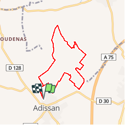

Lengte
8 km

Max. hoogte
134 m

Positief hoogteverschil
128 m
Km-Effort
9,7 km

Min. hoogte
64 m

Negatief hoogteverschil
128 m
Boucle
Ja
Datum van aanmaak :
2014-12-10 00:00:00.0
Laatste wijziging :
2014-12-10 00:00:00.0
2h06
Moeilijkheid : Medium

Gratisgps-wandelapplicatie
 SityTrail
IGN / Geografische instituten
SityTrail Plus
De wereld gaat voor u open
Over ons
Tocht Stappen van 8 km beschikbaar op Occitanië, Hérault, Adissan. Deze tocht wordt voorgesteld door dansmabulle.
Plaatsbepaling
Land:
France
Regio :
Occitanië
Departement/Provincie :
Hérault
Gemeente :
Adissan
Locatie:
Unknown
Vertrek:(Dec)
Vertrek:(UTM)
534474 ; 4820619 (31T) N.
Opmerkingen