


Grèce

GOHIER
Gebruiker

Lengte
256 km

Max. hoogte
1041 m

Positief hoogteverschil
8362 m
Km-Effort
368 km

Min. hoogte
-4 m

Negatief hoogteverschil
8468 m
Boucle
Neen
Datum van aanmaak :
2020-08-08 08:23:28.0
Laatste wijziging :
2020-08-12 08:26:04.486
17h59
Moeilijkheid : Onbekend

Gratisgps-wandelapplicatie
 SityTrail
IGN / Geografische instituten
SityTrail Plus
De wereld gaat voor u open
Over ons
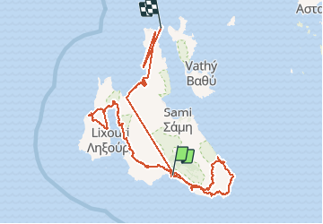
Tocht Auto van 256 km beschikbaar op Peloponnesos, West-Griekenland en Ionische Eilanden, Περιφερειακή Ενότητα Κεφαλληνίας. Deze tocht wordt voorgesteld door GOHIER.
Plaatsbepaling
Land:
Greece
Regio :
Peloponnesos, West-Griekenland en Ionische Eilanden
Departement/Provincie :
Περιφερειακή Ενότητα Κεφαλληνίας
Gemeente :
Λουρδάτα
Locatie:
Unknown
Vertrek:(Dec)
Vertrek:(UTM)
467335 ; 4218934 (34S) N.
Opmerkingen