


Tanniere

PMarter
Gebruiker

Lengte
19 km

Max. hoogte
434 m

Positief hoogteverschil
234 m
Km-Effort
22 km

Min. hoogte
371 m

Negatief hoogteverschil
234 m
Boucle
Ja
Datum van aanmaak :
2020-08-16 08:41:14.246
Laatste wijziging :
2020-08-16 10:46:35.754
2h04
Moeilijkheid : Gemakkelijk

Gratisgps-wandelapplicatie
 SityTrail
IGN / Geografische instituten
SityTrail Plus
De wereld gaat voor u open
Over ons
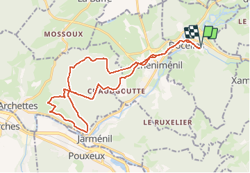
Tocht Mountainbike van 19 km beschikbaar op Grand Est, Vogezen, Docelles. Deze tocht wordt voorgesteld door PMarter.
Plaatsbepaling
Land:
France
Regio :
Grand Est
Departement/Provincie :
Vogezen
Gemeente :
Docelles
Locatie:
Unknown
Vertrek:(Dec)
Vertrek:(UTM)
323317 ; 5334997 (32U) N.
Opmerkingen