


pont tamarins Valbonne

gillou1947
Gebruiker
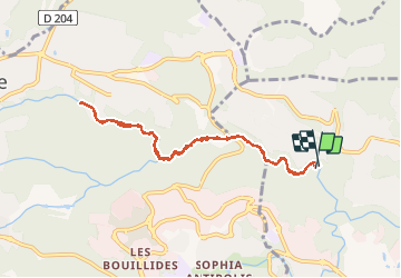

Lengte
8,4 km

Max. hoogte
170 m

Positief hoogteverschil
129 m
Km-Effort
10,2 km

Min. hoogte
74 m

Negatief hoogteverschil
132 m
Boucle
Ja
Datum van aanmaak :
2020-08-19 08:03:30.257
Laatste wijziging :
2020-08-20 06:18:58.448
2h34
Moeilijkheid : Heel gemakkelijk

Gratisgps-wandelapplicatie
 SityTrail
IGN / Geografische instituten
SityTrail Plus
De wereld gaat voor u open
Over ons
Tocht Stappen van 8,4 km beschikbaar op Provence-Alpes-Côte d'Azur, Alpes-Maritimes, Biot. Deze tocht wordt voorgesteld door gillou1947.
Plaatsbepaling
Land:
France
Regio :
Provence-Alpes-Côte d'Azur
Departement/Provincie :
Alpes-Maritimes
Gemeente :
Biot
Locatie:
Unknown
Vertrek:(Dec)
Vertrek:(UTM)
343722 ; 4832749 (32T) N.
Opmerkingen