


pointe cotentin

yvesconnes
Gebruiker

Lengte
14,8 km

Max. hoogte
104 m

Positief hoogteverschil
280 m
Km-Effort
18,2 km

Min. hoogte
0 m

Negatief hoogteverschil
181 m
Boucle
Neen
Datum van aanmaak :
2020-08-23 10:57:12.989
Laatste wijziging :
2020-08-23 14:56:54.799
3h45
Moeilijkheid : Medium

Gratisgps-wandelapplicatie
 SityTrail
IGN / Geografische instituten
SityTrail Plus
De wereld gaat voor u open
Over ons
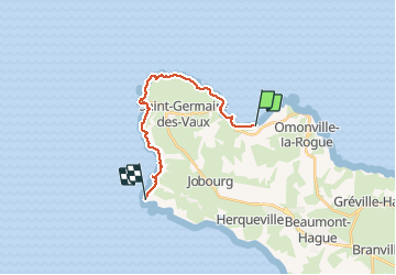
Tocht Stappen van 14,8 km beschikbaar op Normandië, Manche, La Hague. Deze tocht wordt voorgesteld door yvesconnes.
Beschrijving
23/08/20 Xavier à velo et moi à pied
Plaatsbepaling
Land:
France
Regio :
Normandië
Departement/Provincie :
Manche
Gemeente :
La Hague
Locatie:
Omonville-la-Petite
Vertrek:(Dec)
Vertrek:(UTM)
581022 ; 5506608 (30U) N.
Opmerkingen