


Pas de Cere

FOUCAULT
Gebruiker

Lengte
9,3 km

Max. hoogte
776 m

Positief hoogteverschil
175 m
Km-Effort
11,6 km

Min. hoogte
664 m

Negatief hoogteverschil
175 m
Boucle
Ja
Datum van aanmaak :
2020-08-26 09:33:52.0
Laatste wijziging :
2020-08-26 13:56:14.245
4h21
Moeilijkheid : Gemakkelijk

Gratisgps-wandelapplicatie
 SityTrail
IGN / Geografische instituten
SityTrail Plus
De wereld gaat voor u open
Over ons
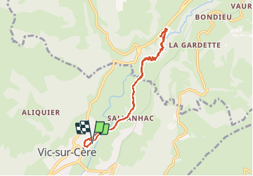
Tocht Stappen van 9,3 km beschikbaar op Auvergne-Rhône-Alpes, Cantal, Vic-sur-Cère. Deze tocht wordt voorgesteld door FOUCAULT.
Beschrijving
Le 26 août 2020
Super ballade
Plaatsbepaling
Land:
France
Regio :
Auvergne-Rhône-Alpes
Departement/Provincie :
Cantal
Gemeente :
Vic-sur-Cère
Locatie:
Unknown
Vertrek:(Dec)
Vertrek:(UTM)
470887 ; 4980989 (31T) N.
Opmerkingen