


Rohrbach groupe

Specialized77
Gebruiker GUIDE
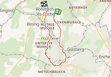

Lengte
11,1 km

Max. hoogte
341 m

Positief hoogteverschil
155 m
Km-Effort
13,2 km

Min. hoogte
255 m

Negatief hoogteverschil
166 m
Boucle
Neen
Datum van aanmaak :
2020-09-01 12:04:30.475
Laatste wijziging :
2020-09-01 15:17:37.994
2h58
Moeilijkheid : Gemakkelijk

Gratisgps-wandelapplicatie
 SityTrail
IGN / Geografische instituten
SityTrail Plus
De wereld gaat voor u open
Over ons
Tocht Stappen van 11,1 km beschikbaar op Grand Est, Moselle, Rohrbach-lès-Bitche. Deze tocht wordt voorgesteld door Specialized77.
Plaatsbepaling
Land:
France
Regio :
Grand Est
Departement/Provincie :
Moselle
Gemeente :
Rohrbach-lès-Bitche
Locatie:
Unknown
Vertrek:(Dec)
Vertrek:(UTM)
373927 ; 5433407 (32U) N.
Opmerkingen