Tocht Stappen Obermorschwiller - Obermorschwiller - Photo
 regisbodilis
regisbodilis

Gebruiker

© OpenStreetMap contributors
Lengte
Lengte
9,6 km
Max. hoogte
Max. hoogte
362 m
Positief hoogteverschil
163 m
Km-Effort
Km-Effort  
11,8 km
Min. hoogte
Min. hoogte
276 m
Negatief hoogteverschil
162 m
Boucle
Boucle
Ja
Datum van aanmaak :
2014-12-10 00:00:00.0
Laatste wijziging :
2014-12-10 00:00:00.0

(0 Bericht)

Stappen
Stappen
2h33
Moeilijkheid : Gemakkelijk

Scan deze QR-code om de tocht te openen in de SityTrail-applicatie

Gratisgps-wandelapplicatie

Logo SityTrail SityTrail

IGN / Geografische instituten

SityTrail uit de App Store downloaden SityTrail uit Google Play downloaden

Logo SityTrail SityTrail World

De wereld gaat voor u open

SityTrail uit de App Store downloaden SityTrail uit Google Play downloaden SityTrail op Huawei AppGallery downloaden

Over ons

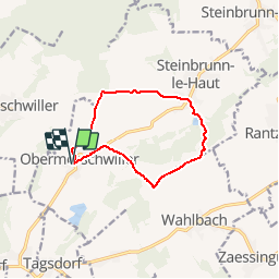
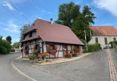
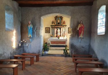
Tocht Stappen van 9,6 km beschikbaar op Grand Est, Haut-Rhin, Obermorschwiller. Deze tocht wordt voorgesteld door regisbodilis.

Beschrijving

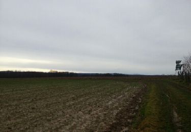
A Obermorschwiller, place de l'église, repérer la balise " disque rouge " et la suivre en direction de Zillisheim : première rue à gauche après l'église, puis chemin à droite. Au croisement avec le GR 532 (Rectangle bleu), poursuivre tout droit sur disque rouge jusqu'au croisement avec le sentier balisé " triangle rouge " au pied du Lilienberg. Prendre le triangle rouge à droite pour arriver à Steinbrunn le Haut.

Suivre la balise " triangle rouge " jusqu'à l'intersection avec le GR 532 " Rectangle jaune ". Prendre le GR en direction de Heilhof et Wahlbach. A Heilhof, prendre à droite le chemin balisé " triangle bleu " jusqu'à l'intersection avec le GR 531 " rectangle bleu " en direction d'Obermorschwiller. Arrivé à la route, rejoindre Obermorschwiller par celle-ci.

Hoogteprofiel

Plaatsbepaling

Land:
France
Regio :
Grand Est
Departement/Provincie :
Haut-Rhin
Gemeente :
Obermorschwiller
Locatie:
Unknown
Vertrek:(Dec)
Vertrek:(UTM)
372991 ; 5278060 (32T) N.

Wandeltochten in de omgeving

Tocht Stappen Wittersdorf - rdpr wittersdorf matin 220208 - Photo
Stappen
GUIDE
stempfel52

Stappen

Medium
Wittersdorf, Grand Est, Haut-Rhin, France
8,8 km | 11,5 km-effort
3h 6min
Ja
Tocht Stappen Illfurth - Illfurth Luemschwillrr Obermorschwiller - Photo
Stappen
selevrich

Stappen

Gemakkelijk
Illfurth, Grand Est, Haut-Rhin, France
28 km | 34 km-effort
3h 28min
Neen
Tocht Stappen Walheim - Walheim-Illfuhrt (1-3-2018) - Photo
Stappen
Richard68500

Stappen

Gemakkelijk
Walheim, Grand Est, Haut-Rhin, France
13,6 km | 18,2 km-effort
3h 32min
Ja
Tocht Lopen Walheim - noel - Photo
Lopen
flip6868

Lopen

Gemakkelijk
Walheim, Grand Est, Haut-Rhin, France
5,3 km | 6,8 km-effort
55min
Ja
Tocht Lopen Walheim - noel - Photo
Lopen
flip6868

Lopen

Gemakkelijk
Walheim, Grand Est, Haut-Rhin, France
5,3 km | 6,8 km-effort
55min
Ja
Tocht Mountainbike Walheim - 2010-10-31 - 10h56m09 - Photo
Mountainbike
sergeh68

Mountainbike

Heel gemakkelijk
Walheim, Grand Est, Haut-Rhin, France
34 km | 42 km-effort
Onbekend
Ja
Tocht Stappen Obermorschwiller - 2022 08 15 - Photo
Stappen
jmbilger

Stappen

Gemakkelijk
Obermorschwiller, Grand Est, Haut-Rhin, France
4,4 km | 5,8 km-effort
1h 12min
Neen
Tocht Stappen Hausgauen - rdpr hausgauen apm 220208 - Photo
Stappen
GUIDE
stempfel52

Stappen

Medium
Hausgauen, Grand Est, Haut-Rhin, France
8,2 km | 10,2 km-effort
2h 26min
Ja
Tocht Stappen Walheim - 2010-11-06 - 16h29m50 - Photo
Stappen
sergeh68

Stappen

Heel gemakkelijk
Walheim, Grand Est, Haut-Rhin, France
11,3 km | 14,3 km-effort
Onbekend
Neen


Sluiten
Mijn abonnementen