


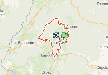
Tour de Fréland par Le Plat

duchaine.nicolas
Gebruiker

Lengte
27 km

Max. hoogte
1141 m

Positief hoogteverschil
918 m
Km-Effort
39 km

Min. hoogte
424 m

Negatief hoogteverschil
920 m
Boucle
Ja
Datum van aanmaak :
2020-09-06 15:03:00.238
Laatste wijziging :
2020-09-07 14:04:54.067
1h56
Moeilijkheid : Gemakkelijk
1h56
Moeilijkheid : Gemakkelijk

Gratisgps-wandelapplicatie
 SityTrail
IGN / Geografische instituten
SityTrail Plus
De wereld gaat voor u open
Over ons
Tocht Mountainbike van 27 km beschikbaar op Grand Est, Haut-Rhin, Fréland. Deze tocht wordt voorgesteld door duchaine.nicolas.
Beschrijving
Ongrange - La Forêt - Chamont - Le Plat - Rehberg - Pierre des 3 Bans - Col de Fréland - Kalblin
Plaatsbepaling
Land:
France
Regio :
Grand Est
Departement/Provincie :
Haut-Rhin
Gemeente :
Fréland
Locatie:
Unknown
Vertrek:(Dec)
Vertrek:(UTM)
365793 ; 5337166 (32U) N.
Opmerkingen