


Hasselfurth BS

bstebe
Gebruiker
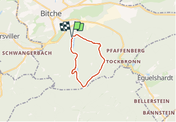

Lengte
8,3 km

Max. hoogte
428 m

Positief hoogteverschil
173 m
Km-Effort
10,6 km

Min. hoogte
294 m

Negatief hoogteverschil
174 m
Boucle
Ja
Datum van aanmaak :
2020-09-18 12:26:11.152
Laatste wijziging :
2020-09-18 15:03:17.519
2h14
Moeilijkheid : Heel gemakkelijk

Gratisgps-wandelapplicatie
 SityTrail
IGN / Geografische instituten
SityTrail Plus
De wereld gaat voor u open
Over ons
Tocht Stappen van 8,3 km beschikbaar op Grand Est, Moselle, Bitche. Deze tocht wordt voorgesteld door bstebe.
Plaatsbepaling
Land:
France
Regio :
Grand Est
Departement/Provincie :
Moselle
Gemeente :
Bitche
Locatie:
Unknown
Vertrek:(Dec)
Vertrek:(UTM)
386038 ; 5433038 (32U) N.
Opmerkingen