


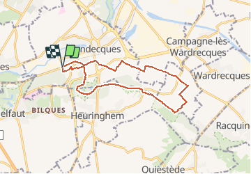
Blendecques 4

alain62rando
Gebruiker

Lengte
12,7 km

Max. hoogte
83 m

Positief hoogteverschil
117 m
Km-Effort
14,3 km

Min. hoogte
18 m

Negatief hoogteverschil
115 m
Boucle
Ja
Datum van aanmaak :
2020-09-19 17:23:36.408
Laatste wijziging :
2020-09-19 17:24:57.163
3h09
Moeilijkheid : Gemakkelijk

Gratisgps-wandelapplicatie
 SityTrail
IGN / Geografische instituten
SityTrail Plus
De wereld gaat voor u open
Over ons
Tocht Stappen van 12,7 km beschikbaar op Hauts-de-France, Pas-de-Calais, Blendecques. Deze tocht wordt voorgesteld door alain62rando.
Beschrijving
Départ des 2 lions
Plaatsbepaling
Land:
France
Regio :
Hauts-de-France
Departement/Provincie :
Pas-de-Calais
Gemeente :
Blendecques
Locatie:
Unknown
Vertrek:(Dec)
Vertrek:(UTM)
448245 ; 5617991 (31U) N.
Opmerkingen