


Stp Mitre par la Grave Etoile

Louis-Christian
Gebruiker
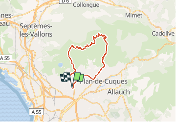

Lengte
24 km

Max. hoogte
517 m

Positief hoogteverschil
572 m
Km-Effort
31 km

Min. hoogte
114 m

Negatief hoogteverschil
570 m
Boucle
Ja
Datum van aanmaak :
2020-09-22 14:02:17.462
Laatste wijziging :
2020-09-22 15:43:59.7
1h41
Moeilijkheid : Heel gemakkelijk

Gratisgps-wandelapplicatie
 SityTrail
IGN / Geografische instituten
SityTrail Plus
De wereld gaat voor u open
Over ons
Tocht Mountainbike van 24 km beschikbaar op Provence-Alpes-Côte d'Azur, Bouches-du-Rhône, Marseille. Deze tocht wordt voorgesteld door Louis-Christian.
Plaatsbepaling
Land:
France
Regio :
Provence-Alpes-Côte d'Azur
Departement/Provincie :
Bouches-du-Rhône
Gemeente :
Marseille
Locatie:
13e Arrondissement
Vertrek:(Dec)
Vertrek:(UTM)
696013 ; 4801286 (31T) N.
Opmerkingen