


2020-10-06_19h49m19_E1

LUTZMarc
Gebruiker
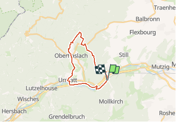

Lengte
19,4 km

Max. hoogte
425 m

Positief hoogteverschil
406 m
Km-Effort
25 km

Min. hoogte
212 m

Negatief hoogteverschil
405 m
Boucle
Ja
Datum van aanmaak :
2020-10-06 17:49:19.572
Laatste wijziging :
2020-10-29 19:12:57.221
5h20
Moeilijkheid : Gemakkelijk

Gratisgps-wandelapplicatie
 SityTrail
IGN / Geografische instituten
SityTrail Plus
De wereld gaat voor u open
Over ons
Tocht Stappen van 19,4 km beschikbaar op Grand Est, Bas-Rhin, Mollkirch. Deze tocht wordt voorgesteld door LUTZMarc.
Beschrijving
Resto à Niederhaslach
Plaatsbepaling
Land:
France
Regio :
Grand Est
Departement/Provincie :
Bas-Rhin
Gemeente :
Mollkirch
Locatie:
Unknown
Vertrek:(Dec)
Vertrek:(UTM)
380498 ; 5376156 (32U) N.
Opmerkingen