


thuillies thuin

schef
Gebruiker
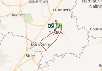

Lengte
7,5 km

Max. hoogte
167 m

Positief hoogteverschil
48 m
Km-Effort
8,1 km

Min. hoogte
147 m

Negatief hoogteverschil
49 m
Boucle
Ja
Datum van aanmaak :
2020-10-14 18:29:12.26
Laatste wijziging :
2020-10-14 18:32:51.298
1h50
Moeilijkheid : Gemakkelijk

Gratisgps-wandelapplicatie
 SityTrail
IGN / Geografische instituten
SityTrail Plus
De wereld gaat voor u open
Over ons
Tocht Noords wandelen van 7,5 km beschikbaar op Wallonië, Henegouwen, Thuin. Deze tocht wordt voorgesteld door schef.
Plaatsbepaling
Land:
Belgium
Regio :
Wallonië
Departement/Provincie :
Henegouwen
Gemeente :
Thuin
Locatie:
Thuillies
Vertrek:(Dec)
Vertrek:(UTM)
594601 ; 5572280 (31U) N.
Opmerkingen