


le dimitile entre-deux

funkady
Gebruiker
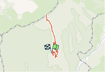

Lengte
9,1 km

Max. hoogte
1859 m

Positief hoogteverschil
801 m
Km-Effort
19,7 km

Min. hoogte
1104 m

Negatief hoogteverschil
796 m
Boucle
Ja
Datum van aanmaak :
2020-10-17 11:11:13.367
Laatste wijziging :
2020-10-17 11:26:27.901
47m
Moeilijkheid : Gemakkelijk

Gratisgps-wandelapplicatie
 SityTrail
IGN / Geografische instituten
SityTrail Plus
De wereld gaat voor u open
Over ons
Tocht Stappen van 9,1 km beschikbaar op Réunion, Onbekend, Entre-Deux. Deze tocht wordt voorgesteld door funkady.
Plaatsbepaling
Land:
France
Regio :
Réunion
Departement/Provincie :
Onbekend
Gemeente :
Entre-Deux
Locatie:
Unknown
Vertrek:(Dec)
Vertrek:(UTM)
343431 ; 7654403 (40K) Z.
Opmerkingen