


vtt

HG74250
Gebruiker
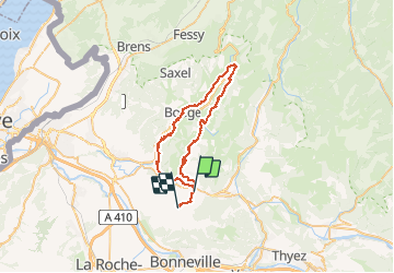

Lengte
43 km

Max. hoogte
992 m

Positief hoogteverschil
923 m
Km-Effort
55 km

Min. hoogte
597 m

Negatief hoogteverschil
891 m
Boucle
Neen
Datum van aanmaak :
2020-10-17 06:37:36.643
Laatste wijziging :
2020-10-21 16:32:22.134
3h45
Moeilijkheid : Moeilijk

Gratisgps-wandelapplicatie
 SityTrail
IGN / Geografische instituten
SityTrail Plus
De wereld gaat voor u open
Over ons
Tocht Mountainbike van 43 km beschikbaar op Auvergne-Rhône-Alpes, Haute-Savoie, La Tour. Deze tocht wordt voorgesteld door HG74250.
Plaatsbepaling
Land:
France
Regio :
Auvergne-Rhône-Alpes
Departement/Provincie :
Haute-Savoie
Gemeente :
La Tour
Locatie:
Unknown
Vertrek:(Dec)
Vertrek:(UTM)
300708 ; 5112742 (32T) N.
Opmerkingen