


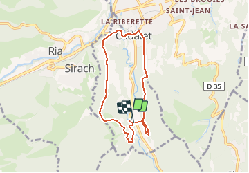
Le Tour de St Michel de Cuxa

Phidel66
Gebruiker

Lengte
6,9 km

Max. hoogte
532 m

Positief hoogteverschil
246 m
Km-Effort
10,2 km

Min. hoogte
364 m

Negatief hoogteverschil
235 m
Boucle
Ja
Datum van aanmaak :
2020-10-28 09:30:40.678
Laatste wijziging :
2020-10-28 09:31:49.631
2h07
Moeilijkheid : Medium

Gratisgps-wandelapplicatie
 SityTrail
IGN / Geografische instituten
SityTrail Plus
De wereld gaat voor u open
Over ons
Tocht Stappen van 6,9 km beschikbaar op Occitanië, Pyrénées-Orientales, Codalet. Deze tocht wordt voorgesteld door Phidel66.
Beschrijving
Boucle Romarins
Plaatsbepaling
Land:
France
Regio :
Occitanië
Departement/Provincie :
Pyrénées-Orientales
Gemeente :
Codalet
Locatie:
Unknown
Vertrek:(Dec)
Vertrek:(UTM)
452097 ; 4715990 (31T) N.
Opmerkingen