


Calmont 2

richardsimopons
Gebruiker
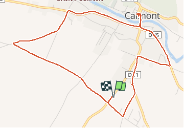

Lengte
6,8 km

Max. hoogte
227 m

Positief hoogteverschil
40 m
Km-Effort
7,4 km

Min. hoogte
209 m

Negatief hoogteverschil
40 m
Boucle
Ja
Datum van aanmaak :
2020-11-06 07:55:44.0
Laatste wijziging :
2020-11-06 09:41:11.665
1h33
Moeilijkheid : Onbekend

Gratisgps-wandelapplicatie
 SityTrail
IGN / Geografische instituten
SityTrail Plus
De wereld gaat voor u open
Over ons
Tocht Stappen van 6,8 km beschikbaar op Occitanië, Haute-Garonne, Calmont. Deze tocht wordt voorgesteld door richardsimopons.
Beschrijving
Boucle de confinement: the best.
Foto's


Plaatsbepaling
Land:
France
Regio :
Occitanië
Departement/Provincie :
Haute-Garonne
Gemeente :
Calmont
Locatie:
Unknown
Vertrek:(Dec)
Vertrek:(UTM)
388713 ; 4792484 (31T) N.
Opmerkingen