


Martelange v1

phugues
Gebruiker
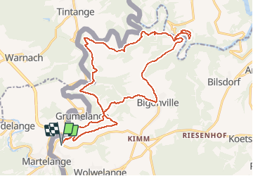

Lengte
21 km

Max. hoogte
494 m

Positief hoogteverschil
689 m
Km-Effort
30 km

Min. hoogte
327 m

Negatief hoogteverschil
690 m
Boucle
Ja
Datum van aanmaak :
2020-11-08 07:27:57.797
Laatste wijziging :
2020-11-08 09:26:47.869
1h42
Moeilijkheid : Gemakkelijk

Gratisgps-wandelapplicatie
 SityTrail
IGN / Geografische instituten
SityTrail Plus
De wereld gaat voor u open
Over ons
Tocht Mountainbike van 21 km beschikbaar op Onbekend, Canton Redange, Rambrouch. Deze tocht wordt voorgesteld door phugues.
Plaatsbepaling
Land:
Luxembourg
Regio :
Onbekend
Departement/Provincie :
Canton Redange
Gemeente :
Rambrouch
Locatie:
Unknown
Vertrek:(Dec)
Vertrek:(UTM)
697406 ; 5524064 (31U) N.
Opmerkingen