


trace-gpx-utds (1)

daniel_2w
Gebruiker
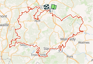

Lengte
157 km

Max. hoogte
697 m

Positief hoogteverschil
4130 m
Km-Effort
212 km

Min. hoogte
160 m

Negatief hoogteverschil
4122 m
Boucle
Ja
Datum van aanmaak :
2020-11-29 21:27:15.429
Laatste wijziging :
2020-11-29 21:29:46.956
--
Moeilijkheid : Zeer moeilijk

Gratisgps-wandelapplicatie
 SityTrail
IGN / Geografische instituten
SityTrail Plus
De wereld gaat voor u open
Over ons
Tocht Trail van 157 km beschikbaar op Wallonië, Luik, Jalhay. Deze tocht wordt voorgesteld door daniel_2w.
Plaatsbepaling
Land:
Belgium
Regio :
Wallonië
Departement/Provincie :
Luik
Gemeente :
Jalhay
Locatie:
Sart
Vertrek:(Dec)
Vertrek:(UTM)
707909 ; 5600252 (31U) N.
Opmerkingen