


Haribo sagries sanilhac chemin des fileuses

Dan30
Gebruiker
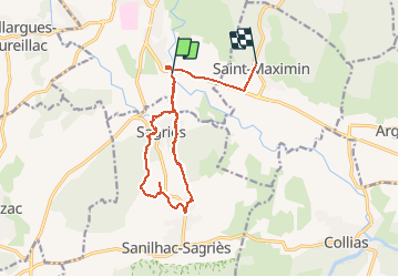

Lengte
14,8 km

Max. hoogte
155 m

Positief hoogteverschil
222 m
Km-Effort
17,5 km

Min. hoogte
57 m

Negatief hoogteverschil
166 m
Boucle
Neen
Datum van aanmaak :
2020-12-03 10:17:19.613
Laatste wijziging :
2020-12-03 15:00:32.787
2h52
Moeilijkheid : Gemakkelijk

Gratisgps-wandelapplicatie
 SityTrail
IGN / Geografische instituten
SityTrail Plus
De wereld gaat voor u open
Over ons
Tocht Stappen van 14,8 km beschikbaar op Occitanië, Gard, Uzès. Deze tocht wordt voorgesteld door Dan30.
Plaatsbepaling
Land:
France
Regio :
Occitanië
Departement/Provincie :
Gard
Gemeente :
Uzès
Locatie:
Unknown
Vertrek:(Dec)
Vertrek:(UTM)
614096 ; 4871972 (31T) N.
Opmerkingen