


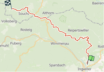
Circuit Alsace Moselle Ingwiller Soucht

Tourisme Equestre Alsace
Promouvoir le Tourisme Equestre en Alsace GUIDE+

Lengte
26 km

Max. hoogte
421 m

Positief hoogteverschil
717 m
Km-Effort
35 km

Min. hoogte
185 m

Negatief hoogteverschil
637 m
Boucle
Neen
Datum van aanmaak :
2020-12-08 18:45:07.745
Laatste wijziging :
2023-10-02 09:44:56.389
4h39
Moeilijkheid : Moeilijk

Gratisgps-wandelapplicatie
 SityTrail
IGN / Geografische instituten
SityTrail Plus
De wereld gaat voor u open
Over ons
Tocht Paardrijden van 26 km beschikbaar op Grand Est, Bas-Rhin, Ingwiller. Deze tocht wordt voorgesteld door Tourisme Equestre Alsace.
Foto's


Plaatsbepaling
Land:
France
Regio :
Grand Est
Departement/Provincie :
Bas-Rhin
Gemeente :
Ingwiller
Locatie:
Unknown
Vertrek:(Dec)
Vertrek:(UTM)
389012 ; 5415106 (32U) N.
Opmerkingen