


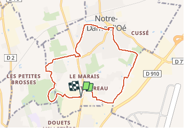
Notre-Dame-d'Oé - PR sud - 8.8km 60m 1h50 - 2020 12 12

Orcal37
Gebruiker GUIDE

Lengte
8,8 km

Max. hoogte
109 m

Positief hoogteverschil
60 m
Km-Effort
9,6 km

Min. hoogte
88 m

Negatief hoogteverschil
60 m
Boucle
Ja
Datum van aanmaak :
2020-12-12 13:00:56.146
Laatste wijziging :
2020-12-12 17:32:33.185
1h50
Moeilijkheid : Heel gemakkelijk

Gratisgps-wandelapplicatie
 SityTrail
IGN / Geografische instituten
SityTrail Plus
De wereld gaat voor u open
Over ons
Tocht Stappen van 8,8 km beschikbaar op Centre-Val de Loire, Indre-et-Loire, Notre-Dame-d'Oé. Deze tocht wordt voorgesteld door Orcal37.
Beschrijving
Notre-Dame-d'Oé - PR sud - 8.8km 60m 1h50 - 2020 12 12
Foto's


Plaatsbepaling
Land:
France
Regio :
Centre-Val de Loire
Departement/Provincie :
Indre-et-Loire
Gemeente :
Notre-Dame-d'Oé
Locatie:
Unknown
Vertrek:(Dec)
Vertrek:(UTM)
326524 ; 5256633 (31T) N.
Opmerkingen