


Sortie Vtt Vivonne

topolino
Gebruiker
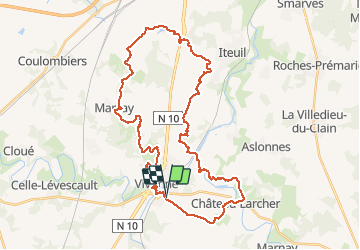

Lengte
40 km

Max. hoogte
150 m

Positief hoogteverschil
490 m
Km-Effort
47 km

Min. hoogte
85 m

Negatief hoogteverschil
489 m
Boucle
Ja
Datum van aanmaak :
2021-01-03 16:58:41.729
Laatste wijziging :
2021-01-03 17:00:10.49
--
Moeilijkheid : Medium

Gratisgps-wandelapplicatie
 SityTrail
IGN / Geografische instituten
SityTrail Plus
De wereld gaat voor u open
Over ons
Tocht Mountainbike van 40 km beschikbaar op Nieuw-Aquitanië, Vienne, Vivonne. Deze tocht wordt voorgesteld door topolino.
Plaatsbepaling
Land:
France
Regio :
Nieuw-Aquitanië
Departement/Provincie :
Vienne
Gemeente :
Vivonne
Locatie:
Unknown
Vertrek:(Dec)
Vertrek:(UTM)
289900 ; 5144360 (31T) N.
Opmerkingen