


Mosnes Loire

Pascal Bernaud
Gebruiker
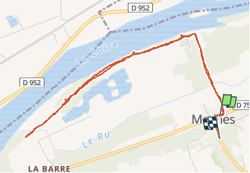

Lengte
6 km

Max. hoogte
80 m

Positief hoogteverschil
46 m
Km-Effort
6,6 km

Min. hoogte
58 m

Negatief hoogteverschil
37 m
Boucle
Neen
Datum van aanmaak :
2021-01-19 15:13:04.0
Laatste wijziging :
2021-01-21 08:05:04.978
1h22
Moeilijkheid : Onbekend

Gratisgps-wandelapplicatie
 SityTrail
IGN / Geografische instituten
SityTrail Plus
De wereld gaat voor u open
Over ons
Tocht Stappen van 6 km beschikbaar op Centre-Val de Loire, Indre-et-Loire, Mosnes. Deze tocht wordt voorgesteld door Pascal Bernaud.
Plaatsbepaling
Land:
France
Regio :
Centre-Val de Loire
Departement/Provincie :
Indre-et-Loire
Gemeente :
Mosnes
Locatie:
Unknown
Vertrek:(Dec)
Vertrek:(UTM)
356820 ; 5257523 (31T) N.
Opmerkingen