


boucle Jalhay

Lychee
Gebruiker
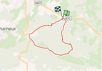

Lengte
6,7 km

Max. hoogte
482 m

Positief hoogteverschil
187 m
Km-Effort
9,3 km

Min. hoogte
333 m

Negatief hoogteverschil
197 m
Boucle
Ja
Datum van aanmaak :
2021-01-21 11:08:27.954
Laatste wijziging :
2021-01-21 13:31:33.542
2h22
Moeilijkheid : Heel gemakkelijk

Gratisgps-wandelapplicatie
 SityTrail
IGN / Geografische instituten
SityTrail Plus
De wereld gaat voor u open
Over ons
Tocht Stappen van 6,7 km beschikbaar op Wallonië, Luik, Jalhay. Deze tocht wordt voorgesteld door Lychee.
Plaatsbepaling
Land:
Belgium
Regio :
Wallonië
Departement/Provincie :
Luik
Gemeente :
Jalhay
Locatie:
Jalhay
Vertrek:(Dec)
Vertrek:(UTM)
711748 ; 5604040 (31U) N.
Opmerkingen