


carces clintest

clintest
Gebruiker
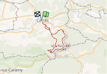

Lengte
12,9 km

Max. hoogte
292 m

Positief hoogteverschil
266 m
Km-Effort
16,5 km

Min. hoogte
133 m

Negatief hoogteverschil
266 m
Boucle
Ja
Datum van aanmaak :
2021-01-25 19:15:35.911
Laatste wijziging :
2021-01-25 19:16:24.582
--
Moeilijkheid : Heel gemakkelijk

Gratisgps-wandelapplicatie
 SityTrail
IGN / Geografische instituten
SityTrail Plus
De wereld gaat voor u open
Over ons
Tocht Te voet van 12,9 km beschikbaar op Provence-Alpes-Côte d'Azur, Var, Carcès. Deze tocht wordt voorgesteld door clintest.
Plaatsbepaling
Land:
France
Regio :
Provence-Alpes-Côte d'Azur
Departement/Provincie :
Var
Gemeente :
Carcès
Locatie:
Unknown
Vertrek:(Dec)
Vertrek:(UTM)
272069 ; 4817458 (32T) N.
Opmerkingen