Tocht Stappen Ponlat-Taillebourg - chapelle st jean ponlat - Photo
 martoche
martoche

Gebruiker

© OpenStreetMap contributors
Lengte
Lengte
6,5 km
Max. hoogte
Max. hoogte
530 m
Positief hoogteverschil
111 m
Km-Effort
Km-Effort  
7,9 km
Min. hoogte
Min. hoogte
448 m
Negatief hoogteverschil
112 m
Boucle
Boucle
Ja
Datum van aanmaak :
2021-01-28 12:51:13.749
Laatste wijziging :
2021-01-28 14:39:46.352

(0 Bericht)

Stappen
Stappen
1h47
Moeilijkheid : Gemakkelijk

Scan deze QR-code om de tocht te openen in de SityTrail-applicatie

Gratisgps-wandelapplicatie

Logo SityTrail SityTrail

IGN / Geografische instituten

SityTrail uit de App Store downloaden SityTrail uit Google Play downloaden

Logo SityTrail SityTrail World

De wereld gaat voor u open

SityTrail uit de App Store downloaden SityTrail uit Google Play downloaden SityTrail op Huawei AppGallery downloaden

Over ons

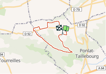
Tocht Stappen van 6,5 km beschikbaar op Occitanië, Haute-Garonne, Ponlat-Taillebourg. Deze tocht wordt voorgesteld door martoche.

Beschrijving

boucle a travers  champs sur piste  oueuse par temps humide

Hoogteprofiel

Plaatsbepaling

Land:
France
Regio :
Occitanië
Departement/Provincie :
Haute-Garonne
Gemeente :
Ponlat-Taillebourg
Locatie:
Unknown
Vertrek:(UTM)
303626 ; 4777110 (31T) N.

Wandeltochten in de omgeving

Tocht Stappen Martres-de-Rivière - cap de  Rouzet en boucle depuis Martres de rivière  - Photo
Stappen
GUIDE
lhomme.ph

Stappen

Gemakkelijk
Martres-de-Rivière, Occitanië, Haute-Garonne, France
11 km | 16,2 km-effort
3h 18min
Ja
Tocht sport Bordes-de-Rivière - 2021-10-31_09h01m59_Cirkwi-Bordes_de_Rivière_Plaine__Les_canaux_d_irrigation_ - Photo
sport
jojo1412

sport

Heel gemakkelijk
Bordes-de-Rivière, Occitanië, Haute-Garonne, France
3,6 km | 3,9 km-effort
Onbekend
Ja
Tocht Stappen Martres-de-Rivière - cap de houcheton depuis Martres de rivière  - Photo
Stappen
GUIDE
lhomme.ph

Stappen

Heel gemakkelijk
Martres-de-Rivière, Occitanië, Haute-Garonne, France
6,8 km | 10 km-effort
3h 28min
Neen
Tocht Stappen Clarac - Clarac, evelyne - Photo
Stappen
Jeanne Pene

Stappen

Heel gemakkelijk
Clarac, Occitanië, Haute-Garonne, France
8,5 km | 10,7 km-effort
2h 13min
Neen
Tocht Lopen Montréjeau - Montrejeau - Photo
Lopen
skwick

Lopen

Gemakkelijk
Montréjeau, Occitanië, Haute-Garonne, France
14,8 km | 18,7 km-effort
1h 54min
Neen
Tocht Stappen Clarac - cier avec evlyne nouveau chemin - Photo
Stappen
Jeanne Pene

Stappen

Heel gemakkelijk
Clarac, Occitanië, Haute-Garonne, France
63 km | 77 km-effort
28h 21min
Neen
Tocht Stappen Clarac - pic - Photo
Stappen
Jeanne Pene

Stappen

Zeer moeilijk
Clarac, Occitanië, Haute-Garonne, France
77 km | 100 km-effort
12h 24min
Neen
Tocht Stappen Clarac - hourquette - Photo
Stappen
Jeanne Pene

Stappen

Zeer moeilijk
Clarac, Occitanië, Haute-Garonne, France
72 km | 91 km-effort
2h 6min
Neen
Tocht Stappen Clarac - ouderou - Photo
Stappen
Jeanne Pene

Stappen

Zeer moeilijk
Clarac, Occitanië, Haute-Garonne, France
91 km | 105 km-effort
67h 54min
Neen


Sluiten
Mijn abonnementen