


Granges de Lars

mitch1952
Gebruiker
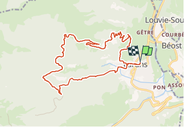

Lengte
11,4 km

Max. hoogte
1175 m

Positief hoogteverschil
710 m
Km-Effort
21 km

Min. hoogte
516 m

Negatief hoogteverschil
710 m
Boucle
Ja
Datum van aanmaak :
2021-02-06 15:29:32.449
Laatste wijziging :
2022-06-07 13:33:14.582
4h43
Moeilijkheid : Zeer moeilijk

Gratisgps-wandelapplicatie
 SityTrail
IGN / Geografische instituten
SityTrail Plus
De wereld gaat voor u open
Over ons
Tocht Stappen van 11,4 km beschikbaar op Nieuw-Aquitanië, Pyrénées-Atlantiques, Laruns. Deze tocht wordt voorgesteld door mitch1952.
Plaatsbepaling
Land:
France
Regio :
Nieuw-Aquitanië
Departement/Provincie :
Pyrénées-Atlantiques
Gemeente :
Laruns
Locatie:
Unknown
Vertrek:(Dec)
Vertrek:(UTM)
709928 ; 4762787 (30T) N.
Opmerkingen