


sortie AU5V

gilbertdu60
Gebruiker
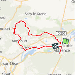

Lengte
30 km

Max. hoogte
99 m

Positief hoogteverschil
304 m
Km-Effort
34 km

Min. hoogte
25 m

Negatief hoogteverschil
242 m
Boucle
Neen
Datum van aanmaak :
2014-12-10 00:00:00.0
Laatste wijziging :
2014-12-10 00:00:00.0
4h29
Moeilijkheid : Medium

Gratisgps-wandelapplicatie
 SityTrail
IGN / Geografische instituten
SityTrail Plus
De wereld gaat voor u open
Over ons
Tocht Fiets van 30 km beschikbaar op Hauts-de-France, Oise, Pont-Sainte-Maxence. Deze tocht wordt voorgesteld door gilbertdu60.
Beschrijving
circuit autour des marais de rosoy et verderonne départ de pont été maxence
Plaatsbepaling
Land:
France
Regio :
Hauts-de-France
Departement/Provincie :
Oise
Gemeente :
Pont-Sainte-Maxence
Locatie:
Unknown
Vertrek:(Dec)
Vertrek:(UTM)
471250 ; 5461044 (31U) N.
Opmerkingen