


2021-02-10_17h14m40_F765

Marin B
Gebruiker

Lengte
12,1 km

Max. hoogte
257 m

Positief hoogteverschil
138 m
Km-Effort
13,9 km

Min. hoogte
205 m

Negatief hoogteverschil
138 m
Boucle
Ja
Datum van aanmaak :
2021-02-10 16:14:42.792
Laatste wijziging :
2022-02-01 11:07:36.091
3h10
Moeilijkheid : Gemakkelijk
3h10
Moeilijkheid : Gemakkelijk

Gratisgps-wandelapplicatie
 SityTrail
IGN / Geografische instituten
SityTrail Plus
De wereld gaat voor u open
Over ons
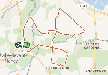
Tocht Te voet van 12,1 km beschikbaar op Grand Est, Meurthe-et-Moselle, Fléville-devant-Nancy. Deze tocht wordt voorgesteld door Marin B.
Beschrijving
Parcours facile avec peu de dénivelé,
A faire par temps sec (surtout vers Gérardcourt - boucle évitable
si non)
Plaatsbepaling
Land:
France
Regio :
Grand Est
Departement/Provincie :
Meurthe-et-Moselle
Gemeente :
Fléville-devant-Nancy
Locatie:
Unknown
Vertrek:(Dec)
Vertrek:(UTM)
294606 ; 5389859 (32U) N.
Opmerkingen