


SityTrail - Les Azimets

m261212
Gebruiker

Lengte
15,9 km

Max. hoogte
688 m

Positief hoogteverschil
339 m
Km-Effort
20 km

Min. hoogte
455 m

Negatief hoogteverschil
343 m
Boucle
Ja
Datum van aanmaak :
2021-02-17 10:57:08.858
Laatste wijziging :
2021-02-17 11:24:10.405
2h48
Moeilijkheid : Moeilijk

Gratisgps-wandelapplicatie
 SityTrail
IGN / Geografische instituten
SityTrail Plus
De wereld gaat voor u open
Over ons
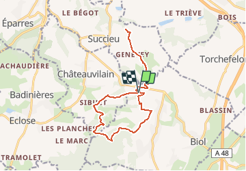
Tocht Stappen van 15,9 km beschikbaar op Auvergne-Rhône-Alpes, Isère, Biol. Deze tocht wordt voorgesteld door m261212.
Plaatsbepaling
Land:
France
Regio :
Auvergne-Rhône-Alpes
Departement/Provincie :
Isère
Gemeente :
Biol
Locatie:
Unknown
Vertrek:(Dec)
Vertrek:(UTM)
684104 ; 5042147 (31T) N.
Opmerkingen