


PHR TM day 27

ARVIEU
Gebruiker

Lengte
8 km

Max. hoogte
2418 m

Positief hoogteverschil
226 m
Km-Effort
14,1 km

Min. hoogte
1273 m

Negatief hoogteverschil
1146 m
Boucle
Neen
Datum van aanmaak :
2021-02-22 08:09:24.226
Laatste wijziging :
2021-02-22 08:12:33.782
3h11
Moeilijkheid : Moeilijk

Gratisgps-wandelapplicatie
 SityTrail
IGN / Geografische instituten
SityTrail Plus
De wereld gaat voor u open
Over ons
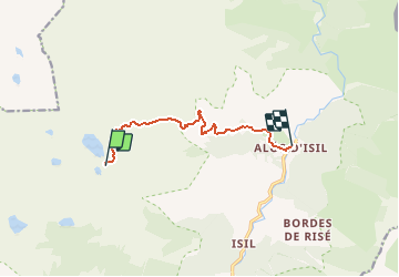
Tocht Stappen van 8 km beschikbaar op Catalonië, Lerida, Alt Àneu. Deze tocht wordt voorgesteld door ARVIEU.
Plaatsbepaling
Land:
Spain
Regio :
Catalonië
Departement/Provincie :
Lerida
Gemeente :
Alt Àneu
Locatie:
Unknown
Vertrek:(Dec)
Vertrek:(UTM)
339629 ; 4728992 (31T) N.
Opmerkingen