


Ruols 5

bouscaillou
Gebruiker
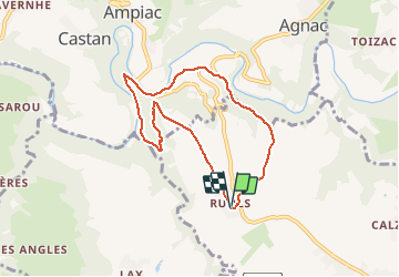

Lengte
7,3 km

Max. hoogte
654 m

Positief hoogteverschil
219 m
Km-Effort
10,2 km

Min. hoogte
483 m

Negatief hoogteverschil
219 m
Boucle
Ja
Datum van aanmaak :
2021-02-24 13:26:06.597
Laatste wijziging :
2021-02-24 15:11:43.178
1h43
Moeilijkheid : Heel gemakkelijk

Gratisgps-wandelapplicatie
 SityTrail
IGN / Geografische instituten
SityTrail Plus
De wereld gaat voor u open
Over ons
Tocht Noords wandelen van 7,3 km beschikbaar op Occitanië, Aveyron, Luc-la-Primaube. Deze tocht wordt voorgesteld door bouscaillou.
Beschrijving
200 m dénivelé
portion chemin caillouteux
Plaatsbepaling
Land:
France
Regio :
Occitanië
Departement/Provincie :
Aveyron
Gemeente :
Luc-la-Primaube
Locatie:
Unknown
Vertrek:(Dec)
Vertrek:(UTM)
460794 ; 4907929 (31T) N.
Opmerkingen