


Chemin de St-Guilhem - étape 04 : Col du Trébatut à La Canourgue

cathel11
Gebruiker
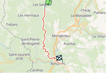

Lengte
16,3 km

Max. hoogte
1101 m

Positief hoogteverschil
239 m
Km-Effort
21 km

Min. hoogte
523 m

Negatief hoogteverschil
767 m
Boucle
Neen
Datum van aanmaak :
2021-02-26 20:22:30.325
Laatste wijziging :
2022-01-16 19:32:16.078
4h49
Moeilijkheid : Zeer moeilijk

Gratisgps-wandelapplicatie
 SityTrail
IGN / Geografische instituten
SityTrail Plus
De wereld gaat voor u open
Over ons
Tocht Stappen van 16,3 km beschikbaar op Occitanië, Lozère, Les Salces. Deze tocht wordt voorgesteld door cathel11.
Plaatsbepaling
Land:
France
Regio :
Occitanië
Departement/Provincie :
Lozère
Gemeente :
Les Salces
Locatie:
Unknown
Vertrek:(Dec)
Vertrek:(UTM)
513545 ; 4930389 (31T) N.
Opmerkingen