


Ride_2021-02-28_ebike-connect

topolino
Gebruiker
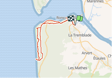

Lengte
33 km

Max. hoogte
32 m

Positief hoogteverschil
223 m
Km-Effort
36 km

Min. hoogte
0 m

Negatief hoogteverschil
222 m
Boucle
Ja
Datum van aanmaak :
2021-03-01 17:14:49.215
Laatste wijziging :
2021-03-01 17:22:33.926
--
Moeilijkheid : Gemakkelijk

Gratisgps-wandelapplicatie
 SityTrail
IGN / Geografische instituten
SityTrail Plus
De wereld gaat voor u open
Over ons
Tocht Mountainbike van 33 km beschikbaar op Nieuw-Aquitanië, Charente-Maritime, La Tremblade. Deze tocht wordt voorgesteld door topolino.
Plaatsbepaling
Land:
France
Regio :
Nieuw-Aquitanië
Departement/Provincie :
Charente-Maritime
Gemeente :
La Tremblade
Locatie:
Unknown
Vertrek:(Dec)
Vertrek:(UTM)
643623 ; 5071617 (30T) N.
Opmerkingen