


la bastide en val

elexine23
Gebruiker
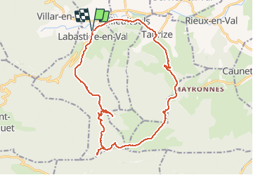

Lengte
19,7 km

Max. hoogte
745 m

Positief hoogteverschil
598 m
Km-Effort
28 km

Min. hoogte
224 m

Negatief hoogteverschil
597 m
Boucle
Ja
Datum van aanmaak :
2021-03-07 07:57:27.211
Laatste wijziging :
2021-03-07 14:42:46.435
6h01
Moeilijkheid : Gemakkelijk

Gratisgps-wandelapplicatie
 SityTrail
IGN / Geografische instituten
SityTrail Plus
De wereld gaat voor u open
Over ons
Tocht Stappen van 19,7 km beschikbaar op Occitanië, Aude, Labastide-en-Val. Deze tocht wordt voorgesteld door elexine23.
Plaatsbepaling
Land:
France
Regio :
Occitanië
Departement/Provincie :
Aude
Gemeente :
Labastide-en-Val
Locatie:
Unknown
Vertrek:(Dec)
Vertrek:(UTM)
457116 ; 4769592 (31T) N.
Opmerkingen